Context

Saxmundham is a market town on the banks of the River Fromus, which functions as an important centre for both the community of Saxmundham and the surrounding towns and villages. The Site lies to the south of the town and is bisected by the A12 and Railway. The adopted Suffolk Coastal Local Plan allocates land to the South of the town for a new Garden Neighbourhood to provide approximately 800 homes, community facilities, a primary and pre-school, and employment provision.

Site Context

The Masterplan Framework has been influenced by local considerations such as the extensive Public Right of Way network between Saxmundham and Benhall, the site’s location on the A12 and its proximity to the existing urban edge of Saxmundham.

The site context plan shows some of the main considerations from an analysis of the local context, which includes an understanding of the history of Saxmundham as a market town and growth following the construction of the railway line, as well as an understanding of the site’s relationship to the surrounding countryside and rural settlements.

View Site Context Plan

Opportunities & Considerations

The site context has informed the opportunities and considerations, and has highlighted key features within and surrounding the site that have fed into the Masterplan Concept.

These key features include:

  • The existing road and railway network
  • Existing railway crossing points
  • The existing Public Rights of Way network
  • The network of drainage ditches and the site’s topography
  • Visual and physical connections to the surrounding landscape and settlements to ensure connected communities
  • Existing landscape and ecological features
  • The urban edge of Saxmundham and opportunities for connections
View Opportunities & Considerations Plan

Land Use

The land uses broadly align with those in the allocation, and comprise of residential, community and employment uses. Our proposal also includes roadside service uses and a hotel to the west of the A12.

A potential location for indoor sports facilities has been identified, however this is outside of the site, but could be underpinned through financial contributions derived from the Garden Neighbourhood development. Other uses to support the residential development including include vast public open space, play and green walking routes.

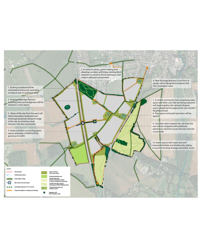
‘Suitable Alternative Natural Greenspace’ (SANG) will be provided in three locations – this is to ensure continued mitigation and protection for nearby Sites of Special Scientific Interest (SSSI) from human activity.

View Land Use Plan

Access & Movement

Connectivity by road, foot, and bike has guided the masterplanning. Existing Public Rights of Way across the site linking to Saxmundham, Benhall, and the countryside will be retained and in many cases enhanced.

Walking and cycle links are being progressed to ensure the Garden Neighbourhood is well integrated into the existing area and encourages the use of Saxmundham’s amenities.

A single junction on the A12 is proposed to access the eastern and western parts of the site while providing improved walking and cycle links and a reduced speed environment.

View Access & Movement Plan

Landscape, Open Space & Recreation

Key environmental features have been retained and form the green and blue (water) infrastructure corridors across the site, ensuring enhanced connectivity between Saxmundham and the open countryside.

The key south-west to north-east walking route across the site will be peppered with informal green spaces and provides connectivity from Saxmundham to the open countryside as well as acting as a network connecting the three areas of Suitable Alternative Green Space (SANG) at the edges of the development.

Existing features of biodiversity value have been retained and areas for Biodiversity Net Gain (BNG) are proposed across the site.

View Landscape, Open Space & Recreation Plan

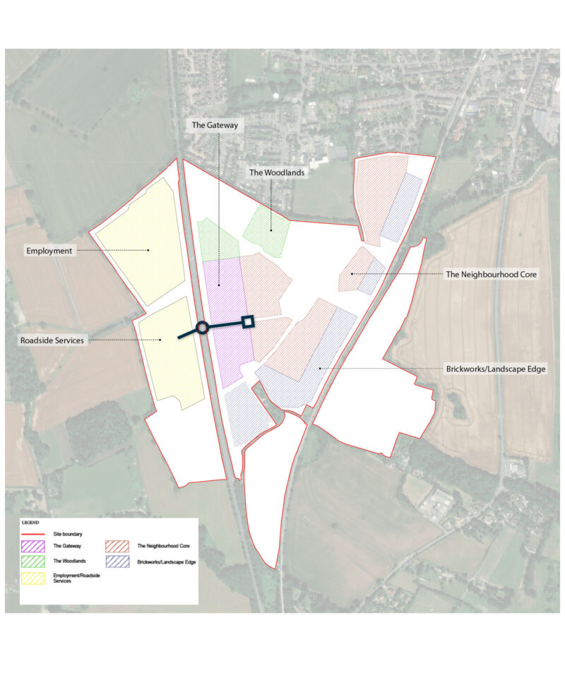
Character Areas & Densities

The garden neighbourhood will be designed in acknowledgement of our guiding development principles, enabling residents to develop a connection to the place in which they live, live healthily and sustainably, and allowing for a variety of greenspace, community, and leisure uses that complements the residential uses.

The character will reflect East Suffolk and the local area, with buildings also responding to their location within the site.

Residential development will be built typically between 20 – 40 dwellings per hectare responding to locations across the site. Residential development will be up to 12m high, and west of the A12 the Services and employment development will be up to 10m and 15m respectively.

View Character Areas Plan

Community Facilities

The new neighbourhood will be integrated into the existing town by the connectivity enhancements to the public right of way network and the proposed community area which will include a school, pre-school, community facilities and community space.

The new school and pre-school will be at the heart of the community area and walking routes in the form of green infrastructure corridors will ensure that the community area is accessible to all residents of the new and existing community.

Couple on bench
Playground